How Google Map's Borders Differ From Country To Country
When I woke up today, an outrageous thought astonished in my mind and it's all about one of the unnoticed things in Google maps. It's all about country borders. We use google maps on our daily basis and we always fail to watch our country borders in Google maps. Country borders are always found to be disputed and no country in the world will leave an inch of their territory to others.
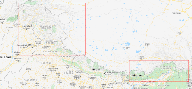
Countries invest billions and billions of money to showcase their strengthen but google found an easy way to do their business. Asian countries contribute about 40% of the google map users. They need customers to use their products and they found a way to do it. They designed the google maps as per the local government. They tend to show different borders of the same country to various countries while browsing. There are about 195 countries in the world and google needs every pinch of personals as users. So this is how google planned the world map to every individual for different countries. Some of the pictures for your references.
 |
| Google map view |
 |
| Google map view |
See those borders it not only about India and China, but there are also a lot more countries in the list and you can use VPN to view the maps from different locations.
Above
images state that how google has toggled the map view from country to
country. Even Yandex and Baidu had done the same. Google represents dotted lines on their map stating the zones are disputed. We need to
observe the changes. There are nearly 29 border issue between countries.
Here listed are the most common ones barring India-Pakistan Issue.
Due to this border issue in Korean countries, S.Korea pays about
1.04 trillion to the U.S under SOFA agreement.
1.04 trillion to the U.S under SOFA agreement.
Google
also solved the border issue with Sudan and South Sudan. With the help
of the local people. This dispute was due to the border region houses
the oil industry and it holds the major GDP of the country. After declaring
the border by the PCA(Permanent Court of Arbitration) and African
government google didn't recognize the border. So moving a step they
utilized the locals to share the new country borders and now google maps
show two different borders as per peoples suggestions. Google maps now
make both country happy which in turn produces users. I also need to
share some interesting facts about google maps.
|
Facts:
- Google Maps reveals the 8th continent "Zealandia"
- Google street view uses tricycle to take the picture at 360' with a 64MP camera and later they stitch the images.
- Google also blurs individual human face to safeguard their privacy but inturn they steal cookies and history to show pop-up ads.
- We can point out the Bermuda triangle, Snake island and northern sentinel islands using google maps. These places cannot be covered by humans.
- The total time spent by users on google map is 2.45 trillion years as of 2014.
To
conclude this google used such a beautiful business algorithm to get
things done. We should also think the problems in all possible outcomes
which makes us as a distinctive person. In future companies like google
will lend their hand to resolve the border issue. This is one of the ways
by which corporates do business all over the world. There's a saying,
which I believe, will fit right for The Google LLC "After you've done a thing the same way for two years, look it over
carefully. After five years, look at it with suspicion. And after ten
years, throw it away and start all over".


Comments